Methods & Data
Full documentation of the datasets, analysis pipeline, and statistics behind the Rebel Reef investigation, written so an independent scientist can review, reproduce, or extend it, and so the work can move toward peer-reviewed publication. This is a pre-expedition, satellite-and-reanalysis study; every claim is stated with its resolution limits and confidence. In-situ validation is the explicit next step (see Open Questions).
1 · Study site
Banco Capiro / Cocalito ("Rebel Reef"), Tela Bay, Honduras (~15.90 °N, 87.48 °W), a turbid, nutrient-loaded nearshore bank reef ~10 km from the Ulúa River mouth. It held anomalously high hard-coral cover (60-70%) through the 2010s despite lethal heat, then suffered mass mortality in 2023. Comparison reefs: Cocalito (15.94 N, 87.55 W), Utila (16.10 N, 86.92 W), Roatán (16.32 N, 86.53 W), Cayos Cochinos (15.98 N, 86.47 W), and Florida Keys (24.66 N, 81.05 W) as a heat-comparison/dead-reef control.
2 · Datasets
All open / free unless noted. Access is programmatic (ERDDAP, Copernicus Marine Toolbox, Google Earth Engine, NASA POWER, PANGAEA).
| Variable | Product | Resolution | Record | Access |
|---|---|---|---|---|
| SST & Degree Heating Weeks | NOAA Coral Reef Watch 5 km (CoralTemp) | 5 km, daily | 1985-2026 | PacIOOS ERDDAP |
| Turbidity (Kd490) & chlorophyll | ESA OC-CCI v6 | 4 km, daily & monthly | 1997-2025 | PML/NOAA COMET ERDDAP |
| Reef-scale chlorophyll | Sentinel-3 OLCI (Copernicus Marine) | 300 m, daily | 2016-2025 | copernicusmarine |
| Dissolved O₂, nitrate, phosphate, silicate, NPP | Copernicus Marine BGC reanalysis (PISCES) | 0.25° (~27 km), daily | 1993-2025 | copernicusmarine |
| Salinity, temperature, mixed-layer depth | GLORYS12 physical reanalysis | 1/12° (~9 km), daily | 1993-2024 | copernicusmarine |
| Rainfall, wind, air temp | NASA POWER; CHIRPS; GPM IMERG; ERA5 | point / 0.05° / 0.1° / 0.25° | 1981/1997/2000/1940- | POWER API; Earth Engine |
| Surface weather obs (storm ground-truth) | Airport METAR/ASOS, MHLC La Ceiba, MHRO Roatán, MHLM San Pedro Sula | hourly + specials, station points | 2023 event window | Iowa Environmental Mesonet |
| High-res imagery (turbidity, SAR) | Sentinel-2 MSI (10 m); Sentinel-1 SAR (10 m); Landsat 8/9 (30 m + 100 m thermal); MODIS/VIIRS | 10-500 m | 2015/2014/1984/2000- | Google Earth Engine |
| Currents (plume model) | GLORYS12 + OceanParcels Lagrangian | 1/12°, daily | 2019-2023 | copernicusmarine / Parcels |
| Carbonate system | PyCO2SYS mixing model | n/a | n/a | open-source |
3 · Analysis pipeline
First-principles mechanism tests, each isolating one hypothesis, plus an integrative index and a cross-site comparison. All code is Python (xarray, pandas, PyCO2SYS, OceanParcels, earthengine-api).
| Step | What it does |
|---|---|
| Thermal stress | 40-yr CoralTemp SST → Maximum Monthly Mean, seasonal range, Degree Heating Weeks for 6 sites. Result: no cool refuge (§2). |
| Ocean color | OC-CCI + Sentinel-3 Kd490/chlorophyll climatology & anomalies; reef-scale plume characterization. |
| Light × heat | Beer-Lambert light-at-depth from measured Kd490, combined with DHW into a depth-resolved bleaching-risk index. |
| Hydrodynamics | GLORYS12 + OceanParcels: sediment-plume residence time; subsurface temperature & Ekman pumping (upwelling test). |
| Carbonate | PyCO2SYS seawater-river mixing → aragonite saturation vs river alkalinity endmember. |
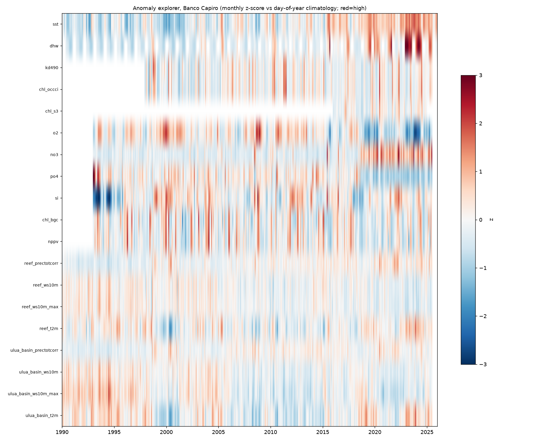
| Master time series | Per-site daily merge of all variables 1990-2026 + day-of-year climatology + z-anomaly; whole-record anomaly detection. |
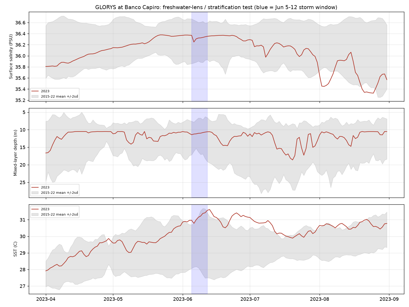
| Freshwater-lens test | GLORYS salinity + mixed-layer depth + SST around the June-2023 event vs baseline (stratification signature). |
| First-flush test | Antecedent-dryness (prior-90-day rain percentile, dry-spell length) of each event's storm, local point vs basin. |
| Setup index | Composite hypoxia-risk index = warm(SST z) + stratified(−mixed-layer z) + calm(−wind z), daily across 2023 & at analog sites. |
| Dry-season-break catalog | All 1990-2024 dry-season-break storms at Tela (3-day pulse ≥45 mm, dry pre-onset antecedent), each profiled for O₂/stratification/turbidity response, ranked by hypoxia-risk. |
| Cross-site parallels | Same signature at documented hypoxia die-offs: East Flower Garden Bank 2016, Bocas del Toro 2017, Mexican Caribbean 2018. |
| Adversarial review | Hostile internal red-team of the herbivory model; a 2×2 factorial + Monte Carlo replaced the discarded "same heat, opposite fate" claim. |
4 · Statistical methods
Anomalies are z-scores against a day-of-year climatology (mean and SD by calendar day, baseline years excluding the event year). The setup index sums the standardized warm, stratified, and calm components. The dry-season-break catalog ranks events by a composite of standardized drought, pulse, warmth, calmness, and stratification. Antecedent dryness is the percentile of the 83-day pre-onset rainfall (ending 7 days before the storm, so a multi-day storm's own rain does not inflate its antecedent) against the same-day-of-year climatology. The herbivory model is a Mumby-type coral/macroalgae/turf bistability model, calibrated (not independently validated) to the 2014-2022 record, with a controlled 2×2 factorial and Monte Carlo over uncertain parameters.
5 · Key results (figures)
Full narrative in The Science. Selected quantitative results:
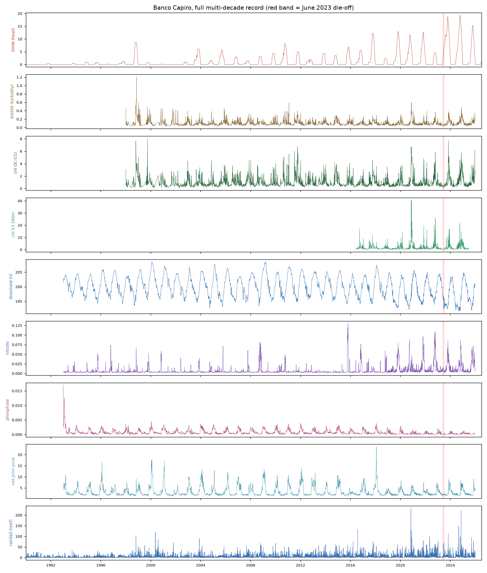
Multi-decade, multi-variable record (6 sites, 1990-2026). Daily SST/DHW, turbidity, chlorophyll, dissolved O₂, nutrients, rainfall and wind, merged per site with full-record anomaly detection.
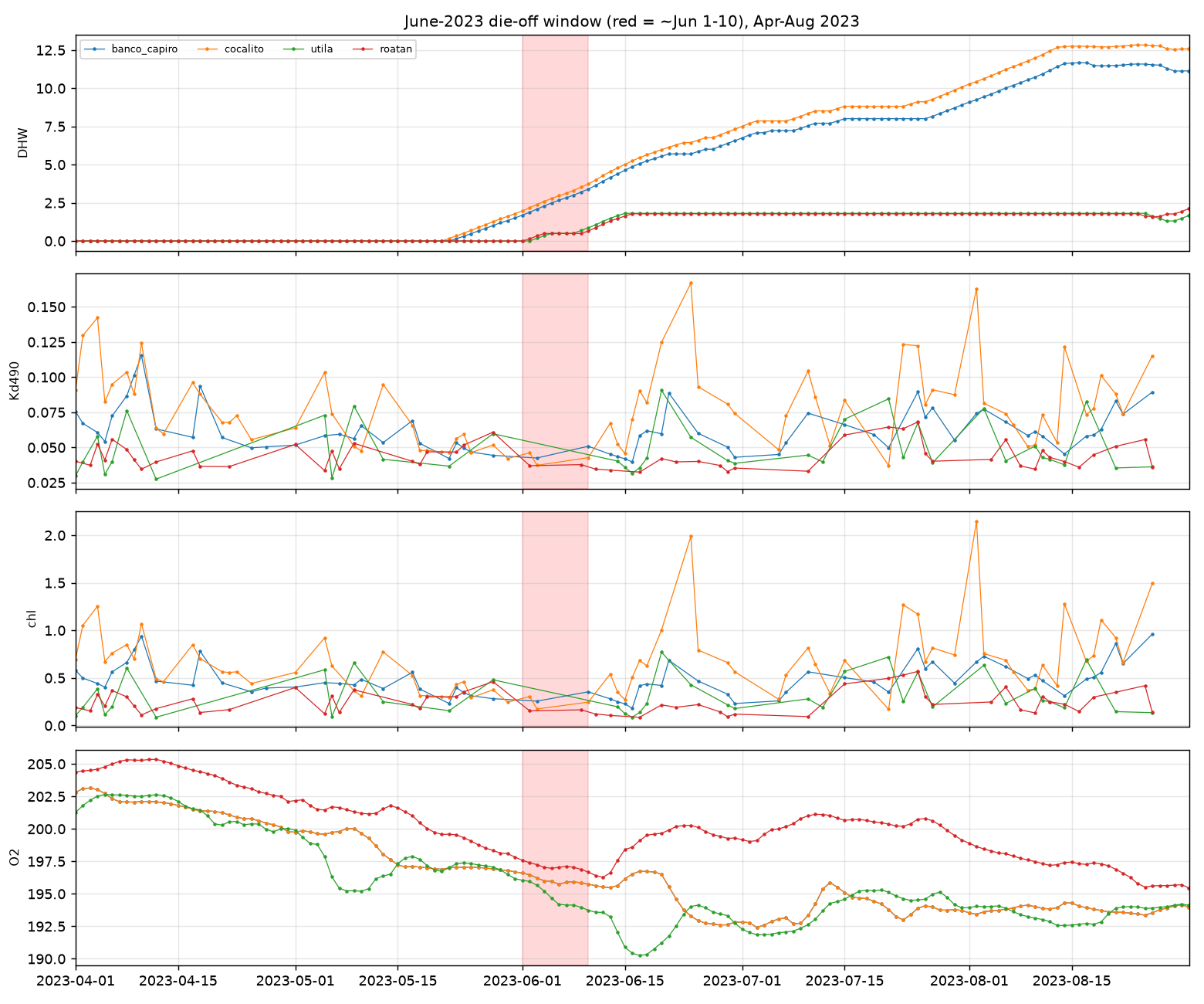
The June-2023 event window. Heat rising, turbidity/chlorophyll cloud-limited, and (from the reanalysis) a warm, stratified water column at the die-off onset. The trigger storm is confirmed by direct surface observations: hourly METAR/ASOS records (Iowa Environmental Mesonet archive) from the three nearest airports, La Ceiba/Golosón (~65 km E), Roatán (offshore) and San Pedro Sula (inland), independently show a thunderstorm tracking from the Caribbean across the coast the night of June 5-6, 2023, with a downburst cold-pool signature at La Ceiba (28→23 °C in ~2 h, saturation, pressure rise, gusts). These stations don't encode rainfall totals, so the storm's magnitude still rests on the gridded rainfall products plus the record-dry antecedent, but its existence, timing and convective character are instrument-confirmed rather than inferred.
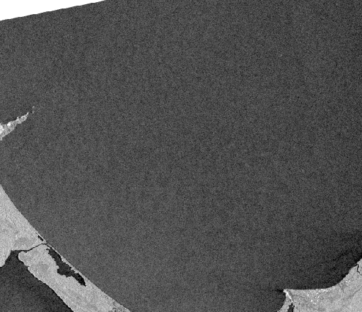
High-resolution imagery could not resolve the event. Sentinel-1 SAR (10 m, cloud-penetrating) shows uniform bay water on June 7, no discrete slick or plume, ruling out a large surface signature and confirming the event was subsurface / sub-grid.
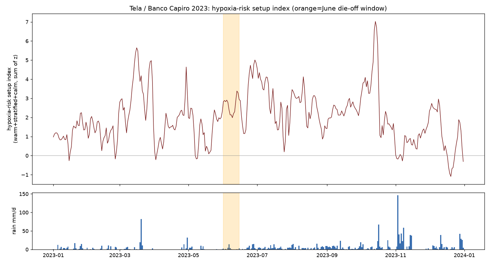
Dry-season-break storm catalog (1990-2024). Only 10 such storms in 34 years; June 2023 ranks #2 by hypoxia-risk composite, and March 2024 ranks #1 (an even more extreme, and recent, setup, a natural experiment worth checking, see Open Questions). O₂ dips after the storm only when it lands on warm, stratified water.

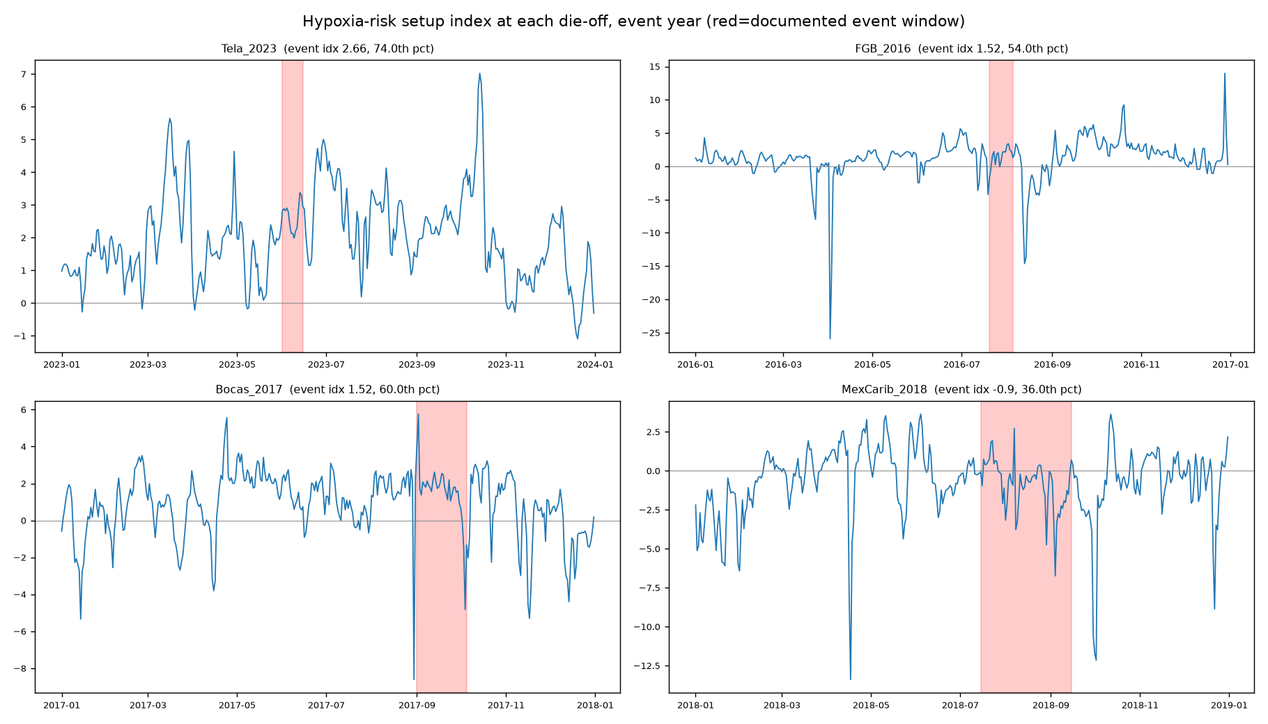
Cross-site parallels. The same setup index at three documented hypoxia die-offs. None occurred at its year's setup peak (all 36th-74th percentile), the die-offs are acute, locally triggered events, and the confirmed freshwater-lens cases (Flower Garden Bank, Bocas del Toro) carry a salinity-drop fingerprint that Tela (a thinner, sub-grid lens) does not resolve.
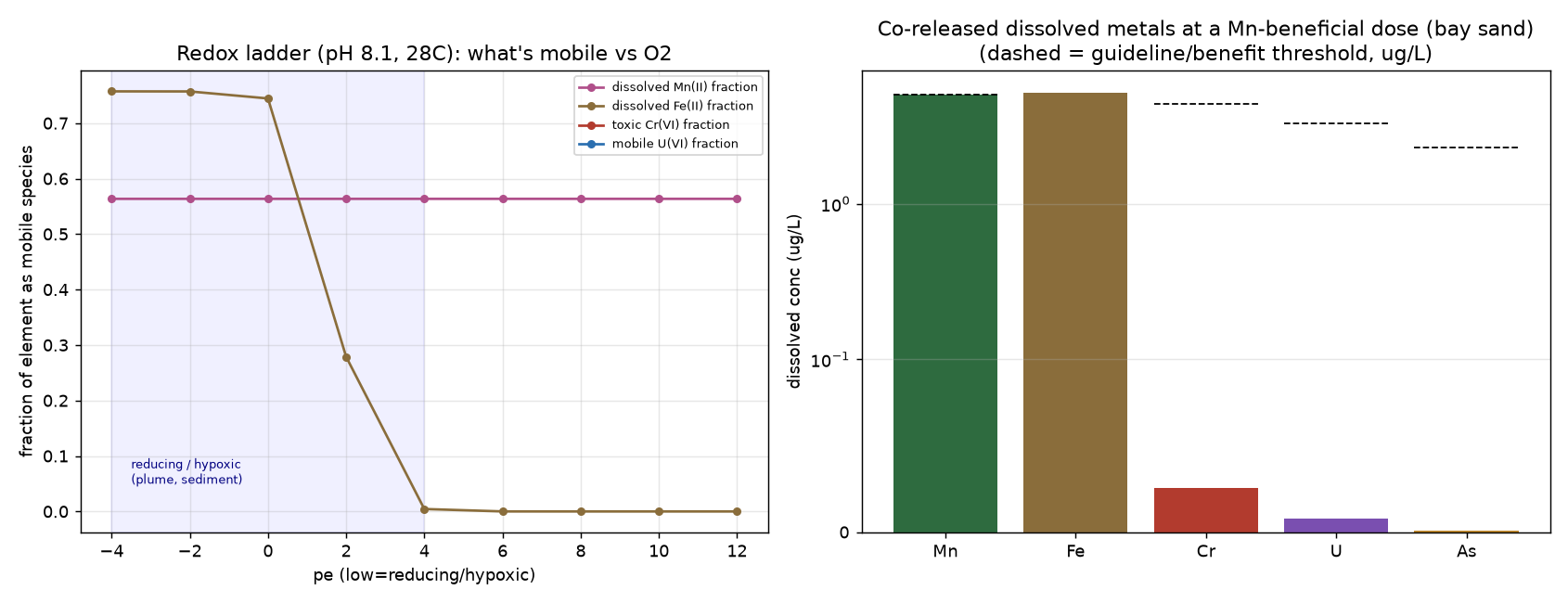
Black-sand geochemistry and redox model. Six XRF scans (two sites, Tela Coral) confirm a heavy-mineral placer sand: ~22-24% Ti (ilmenite/rutile), ~1.6% Mn, ~5% Zr, ~0.5% Cr (chromite), ~350 ppm Th and ~260 ppm U (monazite), with iron site-dependent (~4% in La Ensenada bay sand, ~0% in Los Micos lagoon sand). A PHREEQC redox ladder (pH 8.1, 28 °C, pe -4 to 12) plus a bioavailability-weighted dose model show Mn/Fe oxides reductively dissolving under hypoxia (MnO₂ saturation index crosses zero near pe 8), Ti inert throughout, and, at a Mn-beneficial dose (~5 µg/L), negligible co-release of Cr/U/Th/As (refractory minerals) but ~5 µg/L Fe from the bay sand, above the level where iron alone worsens bleaching. The lagoon (Fe-free) sand is therefore the cleaner treatment candidate. A companion literature review found the exact composition essentially unstudied; the closest analog (Red Sea black sand + heat) reports a synergistic stressor, not a shield. Method: labile-fraction assumptions per mineral phase; database phreeqc.dat (Cr/U handled qualitatively where absent). See The Science §8.
6 · Limitations
- Resolution. Ocean reanalyses are 9-27 km; they cannot resolve a bay-scale (few-km) or thin nearshore freshwater lens. A consistent finding is that the June-2023 event is below the resolution of every satellite and reanalysis product used, subsurface, sub-grid, and cloud-obscured.
- Cloud. Early June 2023 was heavily clouded, defeating optical/ocean-color imagery in the event window.
- Rainfall products disagree on the June-6 storm magnitude (POWER 62 mm, IMERG 20 mm, CHIRPS basin 11 mm) and on antecedent wetness (local point driest-on-record vs basin near-normal); the local point scale is the more relevant to a coastal first flush.
- Calibration, not validation. The herbivory model is calibrated to the 2014-2022 record, magnitudes are not yet fitted to independent data.
- Novel & uncorroborated. Published 2025 papers attribute 2023 Bay-Islands/Honduras mortality to heat + stony-coral-tissue-loss disease; our acute first-flush/hypoxia hypothesis for the discrete June event is not contradicted but not yet corroborated externally. It is a testable claim requiring in-water data.
- Redox model is not a leach assay. The black-sand dose model rests on assumed per-mineral labile fractions, not measured dissolution rates; it predicts what a benchtop leach test (oxic vs anoxic on the actual sand) would confirm or revise. Several literature citations behind the harm/benefit comparison are flagged for independent verification.
7 · Data & code availability
Analysis code (Python) is in the public repository github.com/steps-re/rebel-reef, including the adversarial review (ADVERSARIAL_REVIEW.md). Derived datasets (the per-site daily master time series, the dry-season-break catalog, and event-signature tables) are available on request. All source datasets are public via the providers listed in §2. This is a pre-expedition modeling draft (v1), not peer-reviewed; we welcome review, correction, and collaboration, see Open Questions and Data & Researchers.
Suggested framing for a manuscript: an integrated multi-driver attribution for Banco Capiro (optics + thermal + hydrodynamics + carbonate + herbivory), the physical ruling-out of cooler-water / diverted- plume / upwelling escapes, and a predictive vulnerability framework, plus the novel dry-season-break / first-flush hypoxia hypothesis for the June-2023 event. Co-authors who hold the long-term field data (Operation Wallacea), the symbiont work, and the in-situ observations would be essential.